Can I see more information about a specific aircraft?
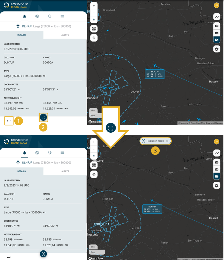
You can show more information about an aircraft by
either clicking on an aircraft in the Alerts tab or on the map.

You will see the following information (if
available) as shown on the dashboard in the picture below. In the label you can
see its callsign and its AGL and AMSL altitude
in feet. The AMSL altitude is corrected for the QNH and temperature at
the closest available airport using the latest published METAR.
Let's take a closer look:
- Go back to the list of traffic. You can also click anywhere on the map to go back to the list of traffic.
- Isolate an aircraft as shown in the figure below.
- This box will appear once an aircraft is isolated. Click on the cross to exit the isolation mode.
Related Articles
What can I expect with the Flight Plans tab?
The Flight Plans tab is designed to help you organize and manage your flight itineraries. Additionally, if your license covers it, you can also view flight plans created in Skeyes Drone and Aeral Activties that are in the area covered by your ...Can I see more information about a specific UAV?
You can show more information about an UAV by either clicking on an UAV in the Alerts tab or on the map. Drones can be identified by their quadcopter icon . Clicking on this icon should reveal a view resembling the screen below. Please be aware that ...How can I create a Flight Plan?
To create a new Flight Plan, click on the "+" icon. This will lead you to the subsequent screen; proceed by following the steps outlined in the images and tables below: STEP 1 - Enter General Flight Plan information Name: enter the name of the Flight ...Drone Analytics - Getting started with the basics 🚀
About SkeyDrone Drone Analytics is a software tool designed for drone detection post-processing. Some fundamentals To be able to easily use the Drone Analytics application, first some fundamentals will be introduced. As a start, the different types ...Can I assign a specific/friendly name to a drone/plane’s series number?
Yes, you can. You can do this: At any time from the Hub Admin (TIS Config page of your organization) During a flight, in Monitor or Drone Radar using the pencil button on the aircraft details. At any time for a whitelisted aircraft, in the settings ...